


US States Map
- Alabama Map
- Alaska Map
- Arizona Map
- Arkansas Map
- California Map
- Colorado Map
- Connecticut Map
- Delaware Map
- Florida Map
- Georgia Map
- Hawaii Map
- Idaho Map
- Illinois Map
- Indiana Map
- Iowa Map
- Kansas Map
- Kentucky Map
- Louisiana Map
- Maine Map
- Maryland Map
- Massachusetts Map
- Michigan Map
- Minnesota Map
- Mississippi Map
- Missouri Map
- Montana Map
- Nebraska Map
- Nevada Map
- New Hampshire Map
- New Jersey Map
- New Mexico Map
- New York Map
- North Carolina Map
- North Dakota Map
- Ohio Map
- Oklahoma Map
- Oregon Map
- Pennsylvania Map
- Rhode Island Map
- South Carolina Map
- South Dakota Map
- Tennessee Map
- Texas Map
- Utah Map
- Vermont Map
- Virginia Map
- Washington Map
- West Virginia Map
- Wisconsin Map
- Wyoming Map
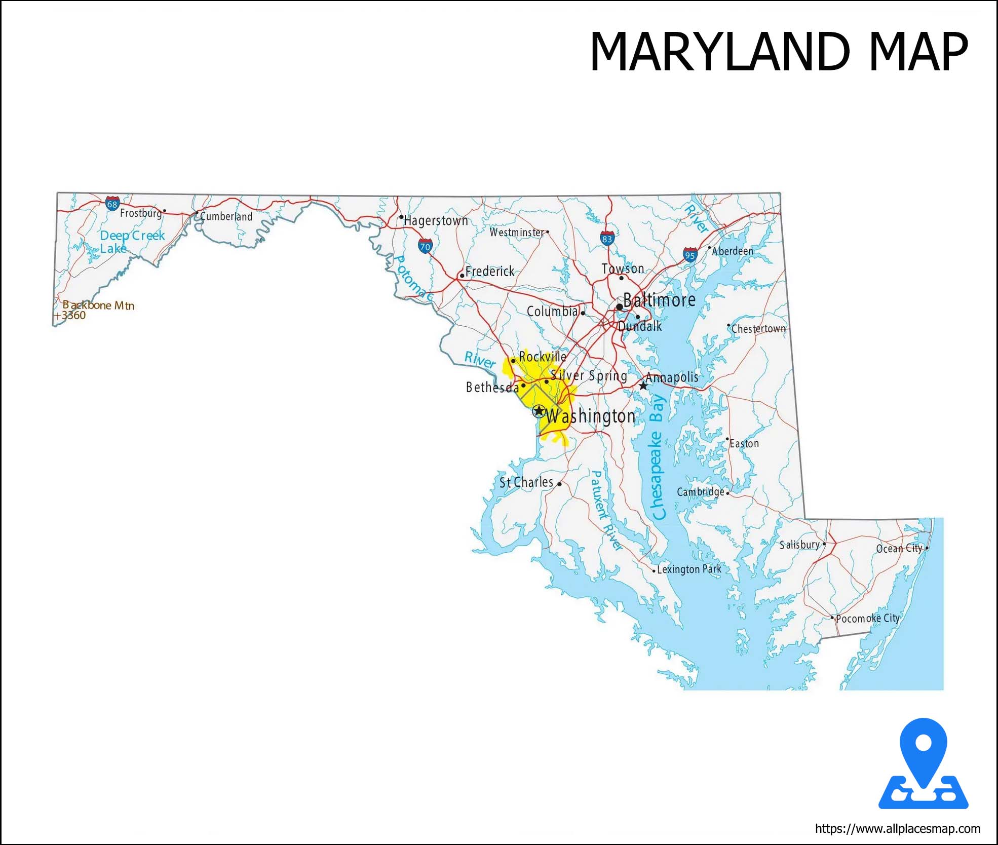
Maryland (MD) Map
Maryland has a tradition of Democratic Party conservatism - Bob Ehrlich
Maryland State Map
History & Geography of Maryland
Maryland is a state located in the Mid-Atlantic region of the United States. Maryland has an area of 12,406.68 square miles 32,133.2 km square it is the 42nd largest and 9th smallest state and is closest in size to the state of Hawaii.
Maryland is a Mid-Atlantic state bordering Virginia, West Virginia, and Washington, D.C. to its south and west; Pennsylvania to its north; and Delaware to its east. That's defined by its abundant waterways and coastlines on the Chesapeake Bay and Atlantic Ocean.
Natural Resources of Maryland
Despite its small size, Maryland enjoys a number of natural resources. It has fertile soil in many areas and a favorable location on Chesapeake Bay. The state's long water frontage on the bay has provided the basis of important shipping and fishing industries.
Economy of Maryland
Although the fishing industry is declining, the catch of fish and shellfish, chiefly from Chesapeake Bay, yielded an income of over $67 million in 1998, and the state's annual catch of crabs is the largest in the nation. The coastal marshes abound in wildfowl. Stone, coal, and iron, mined chiefly in the west of Maryland, are much less significant than in the 19th cent.
Delicacies of Maryland
Maryland farmers grow a variety of fruits and vegetables. It is a complicated mix of history, cultural/ethnic influence, and local commodities. Some states and cities are commonly associated with recipes (Maryland crab cakes, Boston baked beans, Philly cheese steak, New York style pizza) others are moore challenging to connect with a particular dish.
Climate of Maryland
Maryland has two climates. It is continental in the highland west and Average temperatures in western Maryland.
Counties in Maryland
There are twenty-four counties and county-equivalents in the U.S. state of Maryland. Though an independent city rather than a county, the City of Baltimore is considered the equal of a county for most purposes and is a county-equivalent.
Find FIPS Codes
Transportation of Maryland
The Maryland Department of Transportation, headquartered in the Hanover area of unincorporated Anne Arundel County, oversees most transportation in the state through its various administration-level agencies. The independent Maryland Transportation Authority, headquartered in Baltimore, maintains and operates the state's eight toll facilities.
Hotel and Places in Maryland
The US state of Maryland has some Top Tourist sites. National Aquarium, Fort McHenry, American Visionary Art Museum, Deep Creek Lake, Chesapeake and Ohio Canal National Historical Park, B&O Railroad Museum, Oriole Park at Camden Yards, Assateague Island National Seashore and Antietam National Battlefield.
To have a relaxed vacation on your trip to Maryland with the best services, serene environment and luxurious and comfortable furnishing. Here is a list of the top five star hotels in Maryland that will make your stay memorable.
- Four Seasons Hotel Baltimore
- Inn at Perry Cabin by Belmond
- Royal Sonesta Harbor Court Baltimore