


US States Map
- Alabama Map
- Alaska Map
- Arizona Map
- Arkansas Map
- California Map
- Colorado Map
- Connecticut Map
- Delaware Map
- Florida Map
- Georgia Map
- Hawaii Map
- Idaho Map
- Illinois Map
- Indiana Map
- Iowa Map
- Kansas Map
- Kentucky Map
- Louisiana Map
- Maine Map
- Maryland Map
- Massachusetts Map
- Michigan Map
- Minnesota Map
- Mississippi Map
- Missouri Map
- Montana Map
- Nebraska Map
- Nevada Map
- New Hampshire Map
- New Jersey Map
- New Mexico Map
- New York Map
- North Carolina Map
- North Dakota Map
- Ohio Map
- Oklahoma Map
- Oregon Map
- Pennsylvania Map
- Rhode Island Map
- South Carolina Map
- South Dakota Map
- Tennessee Map
- Texas Map
- Utah Map
- Vermont Map
- Virginia Map
- Washington Map
- West Virginia Map
- Wisconsin Map
- Wyoming Map
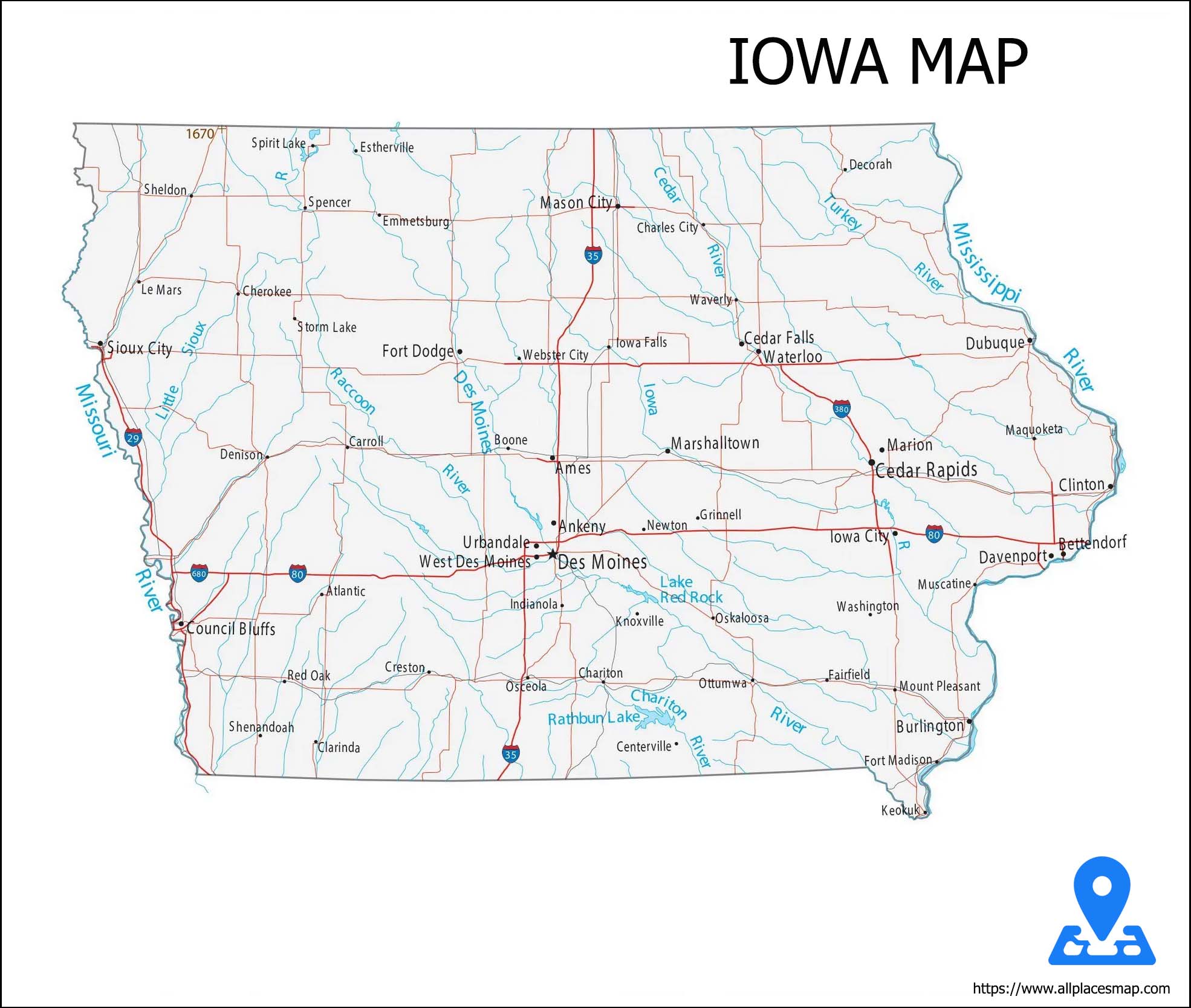
Iowa (IA) Map
Political pandering comes in all shapes and sizes, but every four years the presidential primary bring us in contact with its purest form - praising ethanol subsidies amid the corn fields of Iowa - John Sununu
Iowa State Map
History & Geography of Iowa
A Midwestern U.S. state Iowa is the 26th most extensive in land area and the 30th most populous of the 50 United States. The state capital is Des Moines and was formed on the 28th of December 1846. This State is also known as The Hawkeye State.
Iowa is bordered on two sides by rivers; the Mississippi separates it on the east. Iowa is an area of rich, rolling plains, interrupted by many rivers. The terrain is low and gently sloping, except for the hills in the un-glaciated area of NE Iowa, the steeply sloping bluffs on the banks of the Mississippi, and the mound like bluffs on the banks of the Missouri.
Natural Resources of Iowa
More than four-fifths of the state's total land area is in farms. Iowa's most valuable natural resources are its soil and climate, which make farming and livestock rising so profitable. With most of its area in crops or pasture, it ranks among the top states in extent of farmland.
Economy of Iowa
Agriculture also benefits the state's chief industry, food processing, and in Sioux City and Cedar Rapids many factories process farm products. Nonelectrical machinery, farm machinery, tires, appliances, electronic equipment, and chemicals are among the other manufactures. Cement is the most important mineral product; others are stone, sand, gravel, and gypsum. Mineral production is small, however. Communications finance, and insurance industries are especially important in Des Moines.
Delicacies of Iowa
The fried breaded tenderloin is served on a hamburger bun with condiments is one of the mouth watering foods in Iowa, placed either on top or traditionally under the tenderloin. You will need to buy one long piece of pork tenderloin and slice from it four 5-ounce pieces
Climate of Iowa
The state's temperature varies widely over the year. Iowa generally has hot summers, cold winters, and wet springs because it lies in the humid continental
Counties in Iowa
The US state of Iowa id divided into 99 Districts. The first two counties, Des Moines County and Dubuque County, were created in the mid 18's.
Find FIPS Codes
Transportation of Iowa
Iowa has four primary interstate highways. That travels along the western edge of the state through Council Bluffs and Sioux City, from the Missouri state line to the Minnesota state line through the center of the state, including Des Moines begins just northeast of Davenport, travels from the Nebraska state line to the Illinois state line through the center of the state, including Council Bluffs, Des Moines, Iowa City, and the Quad Cities..
Hotel and Places in Iowa
Iowa tourist's sites include: Blank Park Zoo, Amana Colonies, Iowa State Capital, National Mississippi River Museum, Field Of Dreams, Des Moines Art Centre, Greater Des Moines Botanical Garden, Lost Island Water Park and Adventure land.
The list of five star and luxurious hotels in the US state of Iowa are as follows:
- Des Lux Hotel
- Best Western Plus Dubuque Hotel and Conference Centre