


History of Swaziland
In the kingdom of Swaziland, artifacts indicating human activity dating back to the early stone age 200,000 years ago have been found there and paintings of prehistoric time from art rock can be found in various places. The inhabitants of the regions were Khoisan hunter-gatherers and they were replaced by Bantu migrations hailed from the Great lakes regions of eastern and central Africa. People used to speak in Sotho and Nguni language.Swazi Settler:
They are popularly known as Ngwane, had been settled on the banks of Pongola River. Prior to that, had settled in the area of the Tembe River near present day Maputo.
They established their capital at Zombodze under Sobhuza I, and they conquered the long established clans of the country known to the Swazi as Emakhandzambili. Swaziland derives its name from the later king named Mswati II. KaNgwane named for Ngwane III, is an alternative name for Swaziland the surname of royal. Mswati II was the greatest king and had extended the area of the country twice its current size.
British Rule over Swaziland:
Swaziland became a British protectorate in 1903after British victory in the Anglo-Boer war and in this period, it established the Swazi commercial Amadoda and also established a National school. The election took place and first legislative council constituted on 9th September 1964. The first election under the new constitution took place in 2008 for 55 constituencies and the tenure was five years. During this period there was increased pressure on the government to carry out more reforms; public protest was common. Improvement in SACU receipts, eased fiscal pressure on the government. The new parliament was elected on 20th September 2013 and saw the reappointment of Sibusiso Dlamini, as prime minister for the third time.
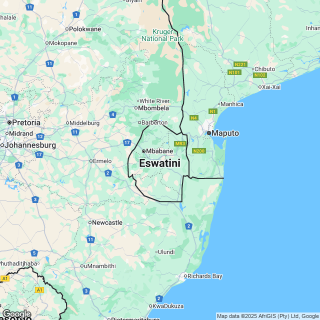
Geography of Swaziland
Swaziland lies across a geological fault which runs from Drskensberg Mountains of Lesotho, and forms the Great Rift Valley of Kenya.Swaziland, a landlocked kingdom, is bordered in North, West and South by the Republic of South Africa and by Mozambique in the East. It has a land area of 17,364 square km. It has four separate geographical regions. These run from North to South and are determined by altitude. It is located at approximately 26 degrees south, 31 degree East. It has a variety of landscapes, from the mountains along the Mozambican border to savannas in the east and rain forest in the northwest.
Along the eastern border is the Lubombo, a mountain ridge, at an altitude of around 600 meters. The mountains are broken by the canyons of three rivers, the Ngwavuma, the Usuts and the Mbuluzi River. Mbabane, the capital, is located on the Highveld.
The most densely populated region of Swaziland is the Middleveld, lying at an average 700 meters above sea level with a lower rainfall than the mountains. The principal commercial and industrial city, Manzini, is situated in the Middleveld.
Climate and Natural Resources of Swaziland
Swaziland is divided into four climatic regions, the Highveld, Middleveld, Lowveld and Lubombo plateau. Rainfalls generally occur during the summer months, often in the form of thunderstorms. The seasons are reverse of those in the Northern hemisphere, with December being mid summer and June mid winter.Highveld in the west, has the highest rainfall between 1000 and 2000 mm and Lowveld in the in the east, records 500 to 900 mm per annum.
The Highveld temperature is temperate and hot while Lowveld may record temperatures around 40 degrees Celsius in summer. Agriculture and manufacturing provide country's major employment.
Tourist Attraction in Swaziland
The tourism sector of the country has given much economic benefit to the country. There are many attractions of the country that attract visitors. The famous tourist places of the country are:- King Sobhuza II Memorial Park, Lobamba
- Phophonyane falls, Peaks peak
- Mkhaya Game Reserve, Mkhaya
- Mlilwane Wildlife Sanctuary, Ezulwini
- Maguga Dam, Piggs Peak
- Hlane Royal National Park, Manzini
- Ngwenya glass, Motshane
- Mantenga Village, Ezulwini
- Swazi Candles, Malkerns
- Bushman Paintings, Sandlane
Famous Hotels in Swaziland
- Foresters Arms
- Mantenga Lodge
- Reillys Rock Hilltop Lodge
- Summerfield Botanical Garden
- The Royal villas
- Royal Swazi Spa
- Happy Valley Hotel and Casino
Swaziland Cuisine
The Swazi social unit is the homestead, a traditional beehive hut thatched with dry grass. Each wife has her own hut and there are three structures for sleeping, cooking and storage. The traditional homestead is the cattle buyer enclosed by large logs interspaced with branches. Cattle buyer is a symbol of prestige and contain sealed grain pits. It is a great hut occupied by the mother of the headman.The traditional diviner is Sangoma, which is chosen by the ancestor of that particular family. The training of Sangoma is called Kwetfwasa'. The diviner is consulted for various reasons �causes of sickness, death.
The nation's most important cultural event is the Incwala ceremony held on the fourth day after the full moon. It is high treason for any other person to hold an Incwala. The climax of the event is the fourth day of the Big Incwala. Important persons are the kings, queen mother, royal wives and children, the royal governors, the chiefs, the regiments and the bemanti or wealthier people.
The well-known cultural event is the annual Umhlanga Reed dance held in the late August or early September. The aim of this event is to preserve girl's chastity, provide tribute labor to the queen mother and to encourage solidarity by working together.
Swaziland is known in the handicraft industry. This business employs over 2500 people, many of whom are women. The product reflects the culture of Swaziland, ranging from housewares, to artistic decorations, to complex glass, stone, or wood art work.
Swaziland's staple food is Sorghum and maize, often served with goat meat, a very popular livestock there. But the cuisine is largely determined by the seasons and the geographical region. The farming industry, mainly depends on sugar cane, tobacco, rice, corns and peanuts. Freshwater produce and imports from coastal from coastal nations are also part of the cuisine of Swaziland.
Traditional Foods:
- Sishwala
- Incwancwa
- Sitfubi
- Siphuphe setindlubu
- Amuse etinkhobe tumble
- Emasi emabele
- Sidvudvu
- Umncweba
- Umkhunsu
- Tinkhobe
International and Domestic Airports in Swaziland
- Matsapha International Airport
- King Mswati III International Airport
Posted By : All Places Map Last Updated: September 13, 2015
Flag of Swaziland

Facts about Swaziland | |
|---|---|
| Country | Swaziland |
| Continent | Africa |
| Capital | Lobamba (royal and legislative) Mbabane (administrative; coordinates below) |
| Government | Monarchy |
| Independence Day | 06 September, 1968 |
| Climate | Tropical and Temperate |
| Area | 17,364 sq km |
| Currency | Lilangeni (SZL) |
| Dialling Code | 268 |
| Neighbours | Mozambique, South Africa |